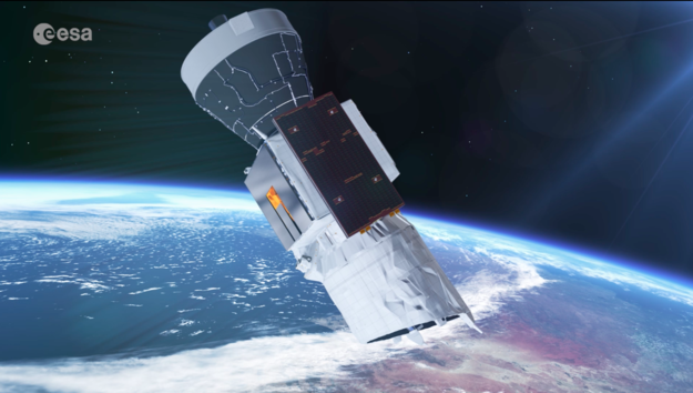
Yesterday, a British-made satellite that launched in the space using powerful Vega rocket from French Guiana at 18:20 local time after a 24-hour delay. The Aeolus spacecraft carries powerful laser technology that will help trace the movement of air particles and also, map winds and its behavior at a global level. The satellite was supposed to launch on Tuesday, however, ironically, the launch was rescheduled to Wednesday after European Space Agency (ESA) discovered about the high-altitude winds that could toss the satellite and it could get haywire.
The satellite named as Aeolus, based on Greek mythology where Aeolus is the god of wind. The spacecraft was launched aboard Vega rocket and carries a Doppler wind lidar system which is an advanced laser system. It shoots pulses of high energy laser in the ultraviolet spectrum that enters the atmosphere and upon hitting air particles, molecules, it scatters and based upon which, the engineers could analyze the data to determine the direction of the wind at different altitudes as well as provide complete medium-range wind forecasts.
As of now, we have several technologies to calculate the various variables of the wind such as weather balloons, whirling anemometers, as well as satellites that forecast wind and its behavior based upon data they collect by tracking clouds in the sky and more. But all these systems have limits that could be overcome with the help of the new satellite that ESA and European Union (EU) launched in partnership under Copernicus project.
The satellite will be located at 320km above the sea level and will scan wind patterns and behaviors from the ground to almost 30km above the sea level that is the stratosphere. This would enable the satellite to forecast weather well in advanced. According to a report published in BBC, Sun dumps all its energy in the tropical regions of the Earth which influence wind patterns and the circulation of wind in the atmosphere which is then distributed in varied directions. Aeolus could help forecast weather both in the trophic region as well as outside where it could increase the accuracy of weather forecast by 2-4 percent when outside and up to 15 percent when in the tropics.
How come this type of satellite wasn’t launched before, you may ask? The answer is, the history of Aeolus dates back to 1999 when it was first approved by the ESA with a scheduled launch in 2007, however, the engineers had trouble adjusting the ultraviolet laser to be mounted on the satellite to work in the conditions that it will experience in the orbit. After years of development, ESA and EU were finally able to develop Aeolus with Arianespace, an Airbus arm, that took few years to materialize.
Moving further, the launch finally happened on Wednesday, August 22. But this is a trail mission that would eventually be lost in the space or say, hurtled towards the atmosphere thereby destroying itself once it comes near the end of its life. ESA has stated that it wouldn’t fund a follow-on mission post-Aeolus which means, other companies could take the mantle of producing and launching the next generation of Aeolus satellite once this current mission goes successfully. Countries like China and the US might be interested in funding such a mission too.